Route Description
Yatoike Park→Yato Pond→Oyamada Ichi-go Ruins→Kami-Oyamada Mitsuya Seseragi Park→The Riverhead Spring of the Tsurumi River→Kami-Oyamada Heights→Yatoike Park
The Tsurumi River is a Class-A river with a total stream length of about 43 km from Tanakayato in Kami-Oyamada to Tokyo Bay. About 1,300 tons of underground water gushes out daily from the spring regarded as its riverhead, and the water is also used for paddy fields.
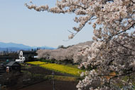
In Oyamada-sakuradai, detached houses and a housing complex attract people’s attention, but there are parks and green spaces left nearby.
* These are estimates given for a person, weight 60kg, moving at 4km per hour, walking 10 min.=30kcal, one step=70cm.
(1.21MB)
* Some details in the PDF walking map may differ from Google Map.
* Contact regarding the PDF walking map offered on this website.
[Machida City Health Center Health Promotion Dept. TEL 042-724-4236]