Route Description
Kitano-tenmansha Shrine→Kitano Sta.→Uchikoshi-benzaiten Shrine→Ishibashiiri Ryokuchi→Kitanodai-wakaba Park→Hakusan Jinja Shrine→Kinunomichi (Silk Road)→Koizumi residence
You can enjoy this course either in the sequence outlined above or in the reverse order from goal to start.
Please choose your departure point according to your preferences.
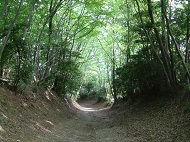
This is a course to heading in the direction of the Koizumi residence following the Tama-kyuryo hills from Kitano Sta. passing the 'silk road' while strolling around the Ryokuchi(green area) and shrines. You can enjoy views such as those of Hachioji streets from Uchikoshi-Benzaiten and those overlooking Mt. Oyama and Mt. Iimori in the distance from Hakusan Jinja Shrine. As this is a course with many ups and downs, please take care of yourself.
* The time, calorie consumption, and number of steps for each walking course were calculated using a speed of 4 km/h, walking 10 minutes = 30 kcal, one step = 70 cm and a body weight of 60 kg.
(0.69MB)
* Some details in the PDF walking map may differ from Google Map.
* Contact regarding the PDF walking map offered on this website.
[Hachioji City Public Health Center ,Health General Administration Section TEL:042-645-5112]