Route Description
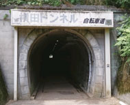
Yokota Tunnel→In front of Kyushoku(school meals) Center→Kabuto-bashi Bridge→Sengen Jinja Shrine→Nakato Community Hall→Banta-ike Pond→Yokota Tunnel
via Akasaka-ike Pond/Akasaka Tunnel:Yokota Tunnel:In front of Kyushoku(school meals) Center→Kabuto-bashi Bridge→Sengen Jinja Shrine→Nakato Community Hall→Banta-ike Pond→Akasaka-ike Pond/Akasaka Tunnel→Banta-ike Pond→Yokota Tunnel
Banta-ike Pond is recorded as the "Mitake no tamei" in the village map of the Edo period and consists of an upper and lower pond. Previously, it was used as an irrigation reservoir for the Iri and Nakato rice fields like the Akasaka-ike Pond.
* The time, calorie consumption, and number of steps for each walking course were calculated using a speed of 4 km/h, walking 10 minutes = 30 kcal, one step = 70 cm and a body weight of 60 kg.
* The time, calorie consumption, and number of steps for each walking course were calculated using a speed of 4 km/h, walking 10 minutes = 30 kcal, one step = 70 cm and a body weight of 60 kg.
(1.38MB)
* Some details in the PDF walking map may differ from Google Map.
* Contact regarding the PDF walking map offered on this website.
[Health and Welfare Department Health Promotion Division, Musashimurayama City (Health care consultation center Forest branch in Ise) TEL 042-654-5421]